bigphotodan.ca

Wednesday, November 30, 2011

Carlsbad Caverns

As I mentionned before we did a detour from El Passo trough the high desert to get to Carlsbad, the reason was to visit the Caverns there.

Well worth the detour

In the past we have explored many caverns such as Lurray in Virginia, Mamouth Caves in Kentuky, Howes Caverns NY, Karshner Caverns in Arizona. The Carlsbad Caverns National Park are the top rated of all caverns in the US and the only ones I visited that are self guided with the use of a tripod permited.

I can see for miles...

But first to get there you need to drive up a 7 miles twisted mountain road with cliftside drops my wife's favorites :) but on the way down she got to see about 50 antelopes going trough the valley beside her. I didn't since I had to keep the eyes on the road and there was no place to stop.
Totem Pole or Rock of Ages

Once you got up the road you get to the welcome center from the height you are you can see for miles. In the visitor center we were sent back to change shoes since the ones we were wearng had been in other caves on the east coast and that so far their bats are not infected with the white nose fungus that is killing the bats on the east coast. That being done there is 2 ways that you can get 750 feet below the earth you can hike down a 2 miles steep trail trough the natural entrance or take an elevator that takes you 75 stories down and right into the caves. We took the elevator because we had time constraint we had to drive another 3 or 4 hours to get to our next stop after the visit..

A Cathedral Celling

There are many tours availables but we choose the Big Room Trail, it take one and a half  hour to go around, the size of it is very impressive, like entering a cathedral, the lighting is extremly well done and perfect for photography. Except for the loud Japanese tourists with flashlights everything is serene, the cavern is big enough to leave them behind while they take picture with flashes. After that it was a suprise at every turn and the best cavern pictures I ever took :)

Early Explorations

We left there and drove to Fort Stockton in Texas at the end of our drive ther was a duststorm, it made it interesting.

We are now in San Antonio, but that will be another story.

Sunday, November 27, 2011

From Yuma to Carlsbad via Las Cruces

So leaving Indio in California we have some serious driving to do the first day's plan was to get to Yuma, visit the prison and sleep there, we decided to push on and try for Gila Bend at the door of the Sonoran National Forest, this way we could stop and sleep in Tuscon to spend some time with a friend that lives there. It didn't work out because they had previous plans for thanksgiving so on the second day we made it to Las Cruses in New Mexico, a good spot to go refill our groceries and since it was Black Friday we also did a bit of shopping, then we hit the road for a third day passing trough El Passo Texas and then driving to Carlsbad New Mexico the site of the famous Carlsbad Caverns National Park, I'll get more into it on my next posting.

Saquaro in the Campsite

As we were arriving at our fisrt stop at Gilla Bend we were passing trough a forest of Saquaro cactus and the sun was setting I was very much in the need to stop and take pictures of them in the sunset, but unfortunatly by the time we were parked the only one available was in the campground and didn't offer much possibilities. Not the shot I had in my head but I did the best I could with it.


Saquaro in Nature

The next day as we crossed the National Forest I pulled over and took some pictures. Then back in the car for the long drive to Las Cruces.

Rock Formations in the National Forest.

So we got to Las Cruces as the night was setting in, we parked on top of a high mesa overlooking the city and we were so tired that we went to bed right away. The next morning when I went outside to walk to the showers it was very cold and we had heavy rain all night. There was a storm front closing in and it was causing the clouds to roll in over the mountains and on the city in the valley down below.

Zoom in on the clouds passing over the mountain

A wide shot with the city of Las Cruces at the foot of the mountains

We then hit the road again with Carlsbad as a destination for today. In order to do so we first have to drive to El Passo and then use secondary road trough the high desert and a mountain range with a low cloud cover. Quite a ride we got ther at sunset once again.

A dry lake in the high desert of New Mexico

El Capitan in Guadeloupe Mountains National Park as we are crossing the mountain pass, we are now only 40 to 45 miles from our destination.

Yuma Territorial Prison

The Guard Tower
First a Prison:

Cells and yard at the Yuma Territorial PrisonThe prison accepted its first inmate on July 1, 1876.For the next 33 years 3,069 prisoners, including 29 women, served sentences there for crimes ranging from murder to polygamy. The prison was under continuous construction with labor provided by the prisoners.
Despite an infamous reputation, written evidence indicates that the prison was humanely administered, and was a model institution for its time. The only punishments were the dark cells for inmates who broke prison regulations, and the ball and chain for those who tried to escape.
In 1909, the last prisoner left the Territorial Prison for the newly constructed Arizona State Prison Complex located in Florence, Arizona.

The Cell Block

Then a High School:
From 1910 to 1914 the Yuma Union High School occupied the buildings. When the school's football team played a game against Phoenix, with Phoenix favored to win, the Phoenix team branded the Yuma team "criminals" when Yuma unexpectedly won the school adopted the mascot with pride, sometimes shortened as the "Crims"; the school mascot image is the face of a hardened criminal, and the student merchandise shop is known as the Cell Block.

Now a Museum:
The prison was barely saved from destruction, empty cells provided free lodging for hobos riding the freights in the 1920s, and sheltered many homeless families during the depression. Townspeople considered the complex a source for free building materials. This, plus fires, weathering, and railroad construction, destroyed the prison walls and all buildings except the cells, main gate and guard tower; but these provide a glimpse of convict life a century ago. It is now an Arizona State Park but even at this it was recently threatened of closure and saved by a local Yuma citizen group.

Another view of the remaining Cell Block

The Salton Sea

When we were stopped in Indio the plan was to go and visit the Salton Sea, California's largest lake it's 35 miles long and 15 miles wide, the surface of the lake is at 227 feet below sea level. In ancient times part of the gulf of California, it became closed off and 2000 years ago it was a giant lake that over time it dried up.
Site of one of the Yacht Clubs that were on the Salton Sea

During the late 1800s, ther was a big planned in a region south of the lake called the Imperial valley. A canal was built to divert water from the Colorado river to irigate the 100,000 acres of fields in the valley.

In 1906 after a very wet winter the swells of the Colorado river broke though the canals and gates and poured in out of control for more then 18 months into the then Salton Sink creating the actual Salton Sea.

Great Egret


By the 1950s the Salton Sea had become a popular resort with 2 yacht clubs, beaches and a championship golf course, by the 1960s the increasing salinity had put an end to the flow of visitors and stuctures, motels, garages, restaurants etc.. became abbandoned and derelics ruins. From a photographic point of view one of the reason I wanted to visit the area, the other being that the Salton Sea is a stop for millions of migrating birds that pass trough the region each years.

Pelicans Feeding

Bombay Beach is a small derelic town on the shores of the Salton Sea, it's a favorite of many photographers for it's post-apocaliptic look, Needless to say that it was on my list but not on my wife's, so I went alone. It was a bit disapointing as some of the famous sights such as the airstream trailer in the sunken trailer park are no more, but still interesting.
Welcome to Bombay Beach

What's left of the sunken trailer park

Tuesday, November 22, 2011

Joshua Tree National Park

Yesterday we went to visit this National Park, we are now camped on the valley floor between the mountains of the National Park on the east and the Sierras on the west the San Andreas fault line runs right under us allong the valley. So once again the day starts with climbing a mountain road, that road was strait and in the desert so the view as we are climbing is awsome. The Cottonwood entrance to the park is about 25 miles away.

Joshua Tree National Park

We brought the dog alone, the planned trip is 5 to 6 hours, she's not aloud on trails but we can take turns staying with the dog, plus the ranger points out some dirt roads where the dog is allowed.

A dirt road in the park

We have more then 50 miles to drive trough the park to cross it from one end to the other, along the way there are interesting trails and interesting viewpoints. the first one on our trail is the chola cactus garden. We left early and the light is low and yellow perfect for pictures.


Chola Cactus Garden
This Chola Cactus is also known as the Jumping Teddy Bear Cactus because of it's soft bristle. However just brushing against it or a soft touch and the spines will detatch and stick on you, hence the Jumping part of the name.

High Altitude in the Park

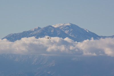
Our last stop in the park was a place called Key View it's an high altitude viewpoint at the top of a winding road, You get a complete view of the valley at the bottom and the Salton Sea on the south. The was an interesting view of Mount San Jacinto that had a cloud ring around the summit.

The Raven Soars towards Mount San Jacinto 10,834 feet (3,302 m)

Saturday, November 19, 2011

San Francisco

On our first day in San Francisco we took the dog along, knowing that she gets tired after a while we came prepared. We brought the special crate thet we have for her, she can be carried like in a pack sac or rolled like airport luggage. It was good that we had it as it was the only way that we coud get on the tour bus with her. We parked at Fisherman's Wharf, it was only $32.00 and then took the tour on a double deck bus with the top deck being opened, without a roof, cold but perfect for photography.

Vanilla and Dan visiting San Francisco

I find these tour bus to be the best way to see most of a big city in a minimal time, you can then decide to go and explore some area more in detail. Usualy you can also hop on and hop off these tours.

Golden Gate Bridge

It went trough the interesting areas such as the Haight and Ashbury, Pacific Heights, The Tenderloin district, Golden Gate park and bridge, Chinatown, Financial district complete with the occupy SF movement and Lombard Street. Also our guide was a movie buff with all the Dirty Harry spots and even the bullit car chase street.

Downtown from Pacific Heights

We got off at Pier 39 and walk back to Fisherman's Wharf to eat a Crab Chowder in a Sourdough bread, a San Francisco staple. The bread has been made by Boudin's Bakery for more then one hundred years, that's how he got rich during the goldrush. Miam Miam. We drove the 45 miles back to our camp we even found a shortcut trough a mountain pass to Halfmoon Bay an then the 1 along the clift, in the dark my wife doesn't mind :)

Alcatraz from Pier 39

We went back the next day without the dog to visit Alcatraz.
You take a ferry at Alcatraz Landing and it brings you to the Island, we ate our lunch on the ferry. You need to have clothes for different occasion for cold, warm or rain, or in our case all three. Wen you land on the platform you have a 15 minutes compulsory briefing and then you go where you want on a self guided visit.

The Guard Tower at the Landing

There is the main cell building that they provide ou with an audio tour kit that is very interesting it includes the cell of the 1962 escape as showned in the Clint Eastwood movie "Escape from Alcatraz".

Escape from Alcatraz

The whole visit can take from 3 to 5 hours to complete we left as the rain began 3 and a half hour later. As we left the fog was rolling in and covering the Golden Gate bridge, what a sight.

Tuesday, November 15, 2011

Pescadero and Surroundings at Sunset:

We needed a few groceries so we decided to drive to Pescadero, about 8 miles from our camp. So I punch in the coordinates into the GPS an then we go, about 3 miles down highway 1 the GPS tells us to turn on a side road, so I take the turn. It happens to be a very narrow winding mountain road with the clift on the passenger side, my wife's favorites :) so after a few miles of oh.. oh.. oh.. watchout, darn GPS we get back to the main road. The town of Pescadero is a quaint little town with organic and whole food markets. We bought an artichoke and garlic bread that was still hot, it smelled darn good in the car comming back to camp.


So to return my wife prefered that we ignored the GPS instructions and that we stay on the main road, fine with me and it was sunset timeas we rode along Highway 1. There is lots of places to stop and take pictures along the road.

We found a nice secluded beach near the Pigeon Point Lighthouse to walk on and take pictures. The waves crashing on the rocks are very relaxing to look at.

So we got back to camp and made some nice BBQ pork chops with the artichoke bread and a local goat cheese.

Moss Landing and the Monterey Region

We decided to Setup camp in Moss Landing a small community 15 miles north of Monterey, there is a few things I want to do in the region one of them is eating at Phil's Fish Market a local restaurant that was on the Food Channel Trowdown with Bobby Flay. So we went to eat there for supper the first night, it was a fun place you pick up a menu at the door and go to the counter to give your order and pay, they then give you a big number and you choose a table, then your waiter finds you. The food was good I had Halibut and my wife had salmon, both very good.

In Moss Landing we are also in the middle of a farming area with a nice farmer's market within walking distance.

The vegetables there are cheap and lots of choice I bought some avocados and made some guacamole I also bought something called Jiacama that I have yet to prepare thanks to Google.

Another project that I had was to go on a boat to do some whale watching, I was worried about being seasick but I was lucky the ocean was realy Pacific :) There was no breaching whales but I got the picture of the tail of a whale named Stinky.
The Tail of Stinky the Whale

There was also a pier full of Sealions that I had researched and programmed in my GPS it just happened that all these activities happened to be within a 1 mile radius from my campsite that I had not planned on sleeping there.

Sealions on Moss Landing Pier

Yesterday we drove into Monterey to the waterfront and we took the 17 miles road that passes trough the Pebble Beach golf course and resort. I had a few spots preprogramed including the famed Lone Cypress, we arrived there at the same time as a bus of Japaneses tourists I was not alone taking pictures :)

The Lone Cypress on the 17 miles drive

My boss had told me before I left to go eat at Peppoli in the Spanish Inn on the Pebble Beach Resort. It's a restaurant owned and operated by the Antinori family and that he would pick up the bill when I return, a very generous offer and I took him up on it, we both had an excellent meal and a glass of wine.

The Pacific at Pebble Beach

So this morning we took the road again and we are now near Pescadero Ca. for a few days.

Saturday, November 12, 2011

The Pacific Coast to Moss Landing:

On Thursday morning we started going u p the coast on California Highway 1, our first stop is Hearst Castle in San Simeon along the coast. The castle sits on a mountain top and was complete with a Zoo and everything. I has been said that Randolph Hearst was the inspiration for Orson Wells Citizen Cane.

The view of the Pacific Ocean from Hearst Castle

 The place is more then impressive filled with artwork and the grounds are incredible with breathtaking view of the Pacific Ocean.
Poolside at Hearst Castle with the Pacific Ocean in the background

The Neptune Pool was the setting in many a movie. Some of the visitors of the castle in the time of Randolph Hearst included, Charlie Chaplin, Howard Hughes and many more. If you pass by it is definitely worth the visit.
We had lunch there and left after, as we kept going north the road got narrower, winding and we were either going uphill or downhill for miles.


The Famous Neptune Pool

With the trailer in tow this panoramic road required all of my attention. Full of blind curves and with the cliff walls overhanging the trailer was passing inches from the rock face wall, my wife didn’t like the road that much good thing she was not on the side of the precipice J .
There was a few overlook, I got to stop and take pictures of the elephant seals basking in the sun on the beach , it was quite a sight.

Elephant Seals on the Beach

The Pacific Coast

Well at 25 mile an hour plus the afternoon traffic in Monterey by the time we got to Moss Landing it was dark again. This morning it was overcast but I got a few picture of the surroundings, the rest of the day was rain so we went to the market to refill our fridge talk about choice at the farmers market, I even bought stuff that I have no idea what they are, I made some fresh guacamole for lunch. Tonight we had supper at a place I had seen on the Food Channel called Phil’s Fish Market.

From Death Valley to the Pacific Coast:

We left early on Wednesday morning our campsite in Pahrump and drove an area they call Death Valley wilderness, my wife renamed it Nowhere and we were in the middle. It’s 50 miles of desert road then an Indian village with a gas station and three buildings then 60 miles of desert road then you hit Interstate 15 and you pass between the bottom of the Death Valley wilderness and the Mojave desert, the view are spectacular.

View of the Mojave Desert on the way to the Coast

There was a ghost town called Calico along the way and I managed to convince my wife to make an unscheduled stop, She agreed “I guess she didn’t remember the last time” so we stopped just before the the entrance to the ghost town and I took a few pictures in particular of a golden eagle that was just beside us.

Golden Eagle

We then get to the town entrance and there is a pay station, anyway I pay the fee and we proceed in, there is an RV parking so we park and start on foot toward the town as we approached I found out it was a renovated ghost town complete with a mini train ride. Not exactly what I was expecting my wife was smiling “I suspect that she knew in advance” but it was fun and nice to visit with an historical background.

Calico Ghost Town

We had lunch there, it was good and we sat outside on a wooden porch with the dog.
We then hit the road again and this time we had to take a small road the 58 the first part is nice enough passing trough farmlands but then we had to cross the Sierras over Bear Mountain at 6900 feet trough Tehachapi pass, the last 100 miles before we hit the coast . It was a white knuckle rollercoaster ride and a race against the sunset trough the mountains.

We got to the coast as the last of the light was disappearing and got to the campsite, parked didn’t even unhooked and went to bed..

Tuesday, November 8, 2011

Death Valley second visit:

Yesterday morning I had to fix the toilet in the trailer, the vaccum gasket of the flush valve was pierced and it leaked water everywhere when it was under pressure. Fortunatly I was able to get a spare part at the RV superstore in Pahrump, also we had battery problems that I was able to fix by installing an external charger maintainer on a separate 110 V line ti works fantastic.

So after lunch we left for Death Valley, it's 45 minutes from our base camp. This time I wanted to see the south side with two sites in perticular, Badwater and Dantes View. Our first stop was Dantes View it starts with a 13 miles drive to climb up the mountain from  1000 feet to 5475 feet with the last mile being a very steep white knuckles clifthanger, My wife had to cover her eyes with her hands, I just love those roads ;)


A look of the Saltflats of Badwater from Dante's View

Whe then arrive to a parking lot with a breathtaking view to Death Valley bellow, There is a half mile trail to the sommet, so I decided to do the trail. The temperature at this altitude is 51F or 10C with a strong gusty wind. I have been going to the gym at the resort for the last few days and after comming back from that trail I don't regret it. The view from the top was incredible you can see the Badwater Saltflats bellow in the valley. So we drove down to Badwater a 30 miles drive dropping from 5475 feet to 282 feet bellow sea level donw at Badwater. My wife had serious problems with the pressure equalisation we even had to stop on the side of the road she was in pain. We made it to Badwater and I went on the trail to take my pictures wile she stayed in the car with the dog who was also acting strange maybee having problems with her ears as well.

Saltflats at Badwater


A closer look

The trail is flat and very easy and the view of the salt flats unlike anything I ever saw, and yes did I mentioned there is no wind and the temperature is 79F or 26C and dry, very dry. We then started our way back to the campsite at sunset and got there in the dark. With the tome changes and all the activities we were very tired and went to bed at 20h30. Tomorow we head for the Pacific Coast.